Overview
Summary
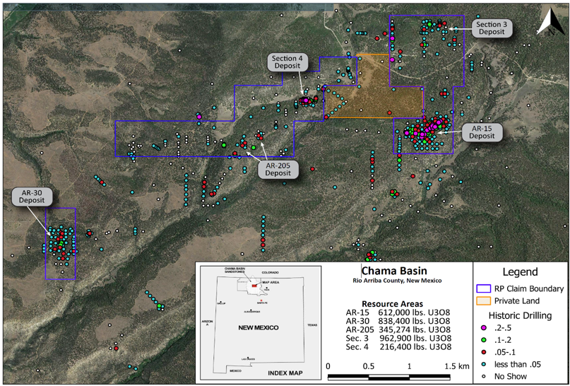
The Mesa Arc Project is an advanced uranium exploration project with strong historical datasets and clear potential for resource growth. Spanning approximately 4,520 acres, the project is centered on a four-mile uranium-mineralized trend with multiple deposits and areas of high-grade potential.
Location and Geology
Located in the Chama Basin, the project sits within the uranium-hosting Jackpile Member of the Jurassic Morrison Formation. Historic work has identified over 2.9 million pounds of U3O8 in the Indicated category across four deposits at a 0.11% cutoff, based on drilling completed on 50-foot centers. Mineralization is strong, with grade thickness values up to 4.8 recorded, and high-grade potential confirmed in the southern claim block, including intercepts such as 10 feet at 1.1% U3O8 in areas with no prior resource estimate.
Exploration
Mesa Arc benefits from extensive historical work, including more than 75,000 metres of drilling, over 1,000 historic drill holes, and gamma-ray probe data. This work supported an internal resource estimate completed by Magnum Uranium Corp. in 2006, which confirmed the uranium mineralized bodies across the trend. Importantly, the potential for strike and down-dip extensions remains open.
Gamma is advancing the project with a planned 10- to 12-hole 6,500-ft drill program designed to twin historical holes and test step-out targets, including the deeper Todilto Formation, which has historically produced more than 17 million pounds of U3O8 but has never been drilled on Gamma’s ground. Permit applications to the U.S. Forest Service are underway, with drilling anticipated to begin in Q2 2026. Results from this program will support a new NI 43-101 compliant mineral resource.
Footnotes:
These estimates are "historic estimates" and are not considered current by GAMA pursuant to NI 43-101. A Qualified Person has not done sufficient work to classify the historical estimates as current mineral resources or mineral reserves and GAMA is not treating the historical estimates as current mineral resources or mineral reserves. The historical mineral resource estimates quoted for the Mesa Arc Project are sourced from internal resource calculations performed by Magnum Uranium Corp. on 6/30/2006. Grade-thickness maps were published and a 'Thiessen Polygon Method' was used to calculate the resource estimates. There was no supporting technical report published with the resource calculation. Data from summary logs of each drill hole giving the depth, thickness and grade of the intercept, was incorporated into a spreadsheet. All uranium grades were given in Ueq (equivalent uranium as determined by down-hole probe). A disequilibrium ratio of Ueq x 1.29 -0.001 was used to estimate the true grade. The true grade x thickness value was then assigned to each polygon. These intercepts were added and a volume was calculated for each hole based on the area x thickness. A tonnage factor of 16 was used in the calculation based on the average density of sandstone. A tonnage was assigned to each polygon (cubic feet of a polygon/16 tons), then the pounds of U3O8 for each polygon was determined. Cut off grade in the calculations was .02 Ueq. TSXV : GAMA GAMA has not undertaken any independent investigation of the sampling, nor has it independently analyzed the results of the historical exploration work in order to verify the results. GAMA considers these historical drill results relevant as the Company is using this data as a guide to plan exploration programs. The Company's current and future exploration work includes verification of the historical data through drilling. Past drilling results may not be reflective of future drilling results.
Maps